About us

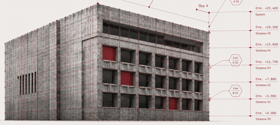
SPLINE.PRO — precise as-built data for design, refurbishment, and operations

We provide laser scanning, measured surveys, BIM modeling and digital documentation for buildings, structures, and sites.

Since 2016 we’ve helped architects, engineers, developers, contractors, and owners obtain accurate geometry without guesswork.

Who we are

SPLINE.PRO is an engineering company in Moscow specializing in laser scanning and digital capture of built assets.

We work at many scales—from apartments and offices to industrial plants, retail, heritage structures, façades, MEP spaces, and full territories.

Our job is to turn a real asset into precise digital outputs: point clouds, drawings, BIM, 3D models, panorama tours, or a full technical documentation pack.

SPLINE.PRO team group photo
  • 2016year founded
  • 5000+successful projects delivered
  • Successwe operate across Russia
Team

How the team works

Join us

Leadership

Field operations

  • Portrait: Vasily

    Vasily

    CEO / Founder

  • Portrait: Maria

    Maria

    Chief operating officer

  • Portrait: Mikhail M.

    Mikhail M.

    Survey engineer (field)

  • Portrait: Kirill

    Kirill

    Survey engineer (field)

  • Portrait: Arthur

    Arthur

    Survey engineer (field)

Office / processing

  • Portrait: Evgeny

    Evgeny

    Lead architectural engineer (office)

  • Portrait: Mikhail Z.

    Mikhail Z.

    Architectural engineer (office)

  • Portrait: Daria

    Daria

    Architectural engineer (office)

  • Portrait: Ilya

    Ilya

    Architectural engineer (office)

  • Portrait: Egor

    Egor

    Architectural engineer (office)

  • Portrait: Natalya

    Natalya

    Architectural engineer (office)

Approach

Our approach

  1. 1

    We clarify the objective first

    Before mobilizing, we confirm what you need data for — design, refurbishment, BIM, compliance, surveys, inspections, or operations. Scanning "everything everywhere" sounds impressive—but it’s rarely the best ROI.
  2. 2

    Pick the methodology

    For each site we choose an optimal workflow: laser scanning, geodetic survey, manual control measurements, photography, panoramic capture, or a combined approach.
  3. 3

    Field work delivery

    Our engineers visit the site, scan/capture systematically, and document structures, openings, networks, façade conditions, elevations, equipment, and all agreed elements.
  4. 4

    Process the data

    After capture we stitch point clouds, verify accuracy, clean noise, decimate where appropriate, and prepare inputs for drafting and BIM.
  5. 5

    Hand over outcomes

    You receive an agreed delivery pack—point clouds, drawings, BIM, 3D models, panorama tours—structured for your workflows and QA.

Quality mark 2025

Trusted with demanding scopes

We build BIM and CAD deliverables from scan data — with models and documentation structured for design teams and approvals.

Ready to join our team?

See open roles

[EN] Already leaving?

[EN] Get a personal commercial offer — leave your contact, we will respond with a timeline and scope.

Go to full form